The Mapping Project at Vijayanagara, India for the Year 2004 (covering the project years 2000-2004)
David Nelson Gimbel, D.Phil. (Oxon)
Archaeos—New York, NY
Abstract
What follows is a description of the Archaeos Mapping Project at Vijayanagara (Hampi), India. It includes a brief overview of the history of the site, explains the foci of Archaeos' work in the areas known as the North Ridge and the Noblemen's Quarters, and provides details concerning the archaeological, topographical, and other methodologies and systems employed by the project.
Historical background
From the beginning of the 14th to the end of the 16th centuries, Vijayanagara, which means "City of Victory" was the capital city of the Sangama (Samgama), Saluva, and Tuluva dynasties in southern India. Founded in 1340, the city is situated on the south bank of the Tungabhadra River in Hampi—a place sacred to the goddess Pampa and her consort Virupaksha, an avatar of the god Shiva. Its settlement followed the incursion of Turkic forces of the Delhi Sultanate into the region, an event that had resulted in the destruction of the local Hindu states.
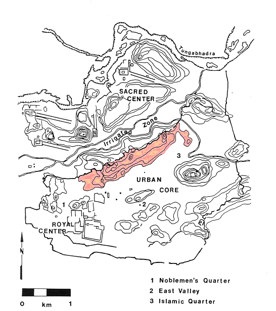
Figure 1: Map of Vijayanagara showing the different quarters and 'conceptual zones' of the city. The Archaeos North Ridge Survey area is highlighted in red (Sinopoli 1993:Fig. 2.1).
The early kings of the Vijayanagara Empire expanded the authority of their state during several generations, expelling the Turkic invaders and preventing the new Deccani Sultans from establishing control over the region for more than two centuries. From Vijayanagara the ruling dynasties governed the most extensive Hindu Empire in the history of the southern India. Their domination of the region, rich in precious stones and metals, resulted in a tremendous period of economic prosperity and in the rapid construction of a monumental capital.
Dominigo Paes, a Portuguese traveler visiting Vijayanagara in the beginning of the sixteenth century, went so far as to compare the city's size, wealth, and population to that of contemporary Rome:
The size of this city I do not write here, because it cannot all be seen from any one spot, but I climbed a hill whence I could see a great part of it... What I saw from thence seemed to me as large as Rome, and very beautiful to the sight... The people of the city are countless in number, so much so that I do not wish to write it down for fear it should be thought fabulous; but I declare that no troops, horse or foot, could break their way through any street or lane, so great are the numbers of the people and elephants. This is the best provided city in the world...i
The archaeological record shows that the core of Vijayanagara (Fig. 1), today known as the "Central City," consisted of a fortified royal residential quarter and a separate series of bordering temple-centered religious communities occupying an area of approximately 25 square kilometersii. The greater fortified Metropolitan Region of Vijayanagara, which today includes many towns and villages such as, Kamalapura, Malpannagudi, Anantashayanagudi, Annagondi, and Hospet, extends to approximately 600 square kilometersiii, making Vijayanagara one of the world's largest ancient cities in terms of size, political, geographical, and economic influence.
In 1565, having dominated the southern Indian subcontinent for nearly two and a half centuries, the Vijayanagara Empire was defeated by a consortium led by the Deccani Sultans. The royal city was sacked; its rulers retreated first to the fort of Penukonda and later to Chandragiri. Historical sources describe the sack of Vijayanagara. Many of its inhabitants were executed and their deteriorating remains piled in pits; wooden gateways, building superstructures, doors, and other architectural features were burnt; statuary was removed from temples, or defaced '. The rubble walls and foundations of many buildings situated on the slopes of hills eventually collapsed, washing down with the surrounding alluvium into the valleys. The debris, in turn, collapsed and buried additional structures at the bases of the slopes.
Several failed attempts were later made to resettle the city and, for a short time, the Deccani Sultans even installed a local governor, but ultimately Vijayanagara was abandoned. Despite the city's destruction and abandonment, however, many of the city's buildings, sculptures and relief works have survived and can be seen today. Once abandoned structures have been repaired and either reoccupied, or repurposed, including complete temple complexes and ancient bazaars.
The current state of the site
Little is known about land usage at Vijayanagara from the period of 1565 to the middle of the 20th century. The habitation of the metropolitan zone probably never wholly ceased and some forms of habitation, as well as worship a number of the city's sacred shrines may have even continued. The majority of the site, however, was eventually reclaimed by the surrounding wilderness. Archaeological investigations and records, including a map of the site made in 1799 by the British authorities suggest that some agriculture may have continued around the ruins of the central city for approximately 200 years. But, the exact extent of such land use and of local habitation after the destruction remains uncertain.
In the 20th century, however, the city again became a significant pilgrimage, agricultural, economic, and tourist district. Today, Vijayanagara lies within the center of a series of densely populated agricultural, economic, and spiritual communities whose needs profoundly impact the site's archaeological remains.
Although many of the city's temples, walls, and other structures still stand, a great many continue to be stripped of building materials in order to build farmers' walls, construct new buildings, or clear new fields to make way for agricultural development. Ongoing, threats to the site include; climactic and ecological issues; the effects of human habitation and economic development; agricultural needs; religious and political pressures; the requirements of tourism, and the proposed construction a major road, a pedestrian bridge, and a vehicular bridge that are intended to pass through the ancient ruins of Hampi and Anagondi on separate sides of the Tungabhadra River. The main purpose of the proposed road—which pays little genuine consideration to its impact upon the ruins of the ancient site—is to shorten the distance of a major trucking route that passes through the area and connects with the neighboring city of Hospet.
Impetus and goals
In an attempt to better understand the historical uses of urban space at the city, Archaeos, a non-profit research organization based in New York City, has been conducting a mapping project since December of 2000 that focuses upon two areas near the Royal Center: the North Ridge and the Noblemen's Quarter.
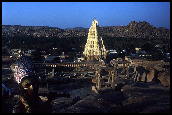
Figure 2: View of the Virupaksha Temple from Hemakuta Hill.
The project, which is affiliated with the Karnataka Directorate of Archaeology and Museums, with Kannada University, and with the American Institute of Indian Studies, is intended to document the remains in these two areas and to provide a better understanding of the ancient uses of the urban space.
The conceptual 'zones' of the city
The remains of Vijayanagara can be divided, conceptually and geographically, into several different zones (see Fig. 1). The first of these, known as the Sacred Center, includes the Virupaksha temple, which lies on the south bank of the Tungabhadra River, at the northwest corner of the site. This area extends for approximately 4 km along the riverbank and is densely populated by four monumental temple complexes, as well as numerous smaller temples, shrines, and carved religious imagesiv.
A granite ridge, dominated by several features including Matanga Hill (the highest point in the region and the site of a sacred shrine dedicated to Hanuman) and Hemakuta Hill, (an area immediately above and to the South of Hampi containing numerous pre-Vijayanagara period temples) runs roughly southwest to northeast and separates the Sacred Center from an agriculturally rich valley known as the Irrigated Zone.
Even further to the South, a second topographical feature, the North Ridge, also runs roughly southwest to the northeast. This feature acts as the northern boundary of the Urban Core and as a natural fortification for it. Its fortification aspect was enhanced in ancient times by the construction of a massive defensive wall, containing gates, and ramparts across the ridge's span. The city wall comprises part of a larger system of man-made fortifications that surrounds the Urban Corev in the rough form of an oval.
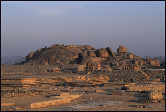
Figure 3: View of a ceremonial area within the Royal Center.
The Royal Center, at the southwest end, of the Urban Core, contains the palace of the ruler and numerous religious, performative, and secular structures associated with the court: temple complexes, shrines, platforms, wells, aqueducts, audience halls, pavilions, elephant stables, and administrative structures (Fig. 3). At the northeastern end of the Urban Corevi lies the so-called "Muslim Quarter" a zone containing both Hindu temple complexes and numerous mosques and tombs, many built by high-ranking members of the royal army.
Techniques and data collection
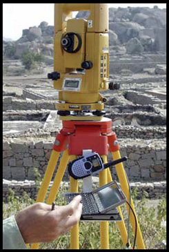
Figure 4: Total Station with attached palmtop computer for data collection.
As mentioned above, the Archaeos Mapping Project focuses upon two limited sections of the Urban Core: the North Ridge and the Noblemen's Quarter. The project's primary tools for data capture are total stations. These instruments are coupled to handheld computers using modified software for field surveying (Fig. 4). Other tools and techniques that we rely upon include: computer assisted design (CAD) programs; the global positioning system (GPS); digital photography; and digital video.
The project's aim is bi-fold: both capture as much archaeological data as possible and to record the process of mapping and working at the site for use by current and future researchers and educators. We believe that the instruments and techniques that we are using at Vijayanagara, in conjunction with other technological advances, not yet employed by us—for example: remote sensing, GIS, and satellite imaging—will eventually become standard parts of the toolkit used by archaeologists, historians, and cultural resource managers.
The Surveying grid and its boundaries
The North Ridge at Vijayanagara covers an area more than two kilometers in length. Very little is known about the uses of urban space in this area and little documentation exists for the majority of the archaeological features.
Our first step was therefore to conduct a visual study of the area and to determine and initial geographical focus. We decided that we should initially focus upon an area of approximately 150,000 to 165,000 square meters, situated along the southwestern end of the North Ridge. In this sector, there is a very high density of building remains, including several small temple complexes, shrines, a palace, or administrative complex, and at least one large, elite semi-residential complex.
Because of the lack of accurate and known surveying benchmarks, several closed triangular traverses were calculated, beginning with station points 'A1', 'A2', and 'A3' (Fig. 5). First 'true north' was determined by means of reference to Polaris. Then, coordinate values were calculated accordingly. Once the accuracy of the primary traverse between A1, A2, and A3 was established, the grid was extended to include an additional 7 permanent control stations ('A4' to 'A10'), resulting in a mesh of interlocking triangulations covering the intended survey areas. Each station point was then marked and numbered using a bronze disk. The stations were photographed and GPS readings were taken in order to relocate them in the future. All this information, along with Archaeos' own internal grid coordinates for the each control station is available on the web for use by surveyors, archaeologists, or any other interested parties vii.
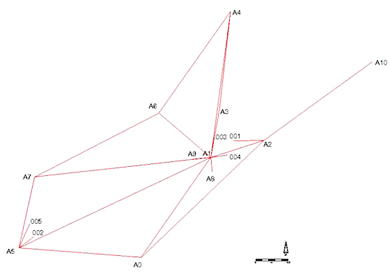
Figure 5: Diagram of control stations, substations, and triangulations.
Structuring data collection and preparing the survey area
Our project at Vijayanagara represents an ongoing series of experiments about how archaeological data is collected, modeled, and interpreted.
One of the project's primary goals is that each and every surveying point shot at the site should be linked to as many relevant and nested categories of information about it as can reasonably be recorded. This goal has both a personal and a historical basis. During an earlier excavation season at Tell Arbid in northern Syria in 1999viii, Archaeos and the Oriental Institute of the University of Vienna experimented with ways to use small digital data collectors linked to total stations. These we used in order to record nested categories of information about each survey point. We hoped that, by doing so, we would be able to begin to formulate ways of maintaining higher levels of data integrity and data capture than have been traditionally possible through analog means.
During the Tell Arbid excavation, data collectors were individually programmed with categories of information and with codes that were specific to Near Eastern archaeology. The programming allowed us to perform basic mapping functions and to place artifacts within a 3-dimensional context and coordinate system while also including several levels of data pertaining to each object.
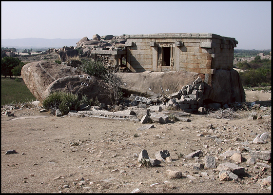
Figure 6: View of a religious structure, situated at the edge of a 'rubble field' on the North Ridge—diagnostic features have been outlined in white lime paint.
That type of surveying, which will increasingly become the norm in archaeological fieldwork, represents a change from 'traditional' methods of recording and classifying archaeological finds. Traditionally, handwritten field books were employed and filled with sketched illustrations of locations, based upon using measurements made using hand tapes.
When we began our work at Vijayanagara, the methods that we are using there were still largely uncommon. We, therefore, had to assemble a variety of hardware and software components and to actually write software scripts in order to transport the data from one system to another. As such technologies become more integrated, however, this type of customization will hopefully cease to be necessary.
In surface archaeology projects such as the one at Vijayanagara, where no excavation is involved, the aim is to record only those diagnostic and physical features visible above or on the actual ground. This requires first identifying and listing features.
The initial survey area contains many tens of thousands of pertinent features. In order to prepare the survey area, workers first removed brush, cacti, and other obstructions. Individual features, such as wall alignments, rock cut steps, relief works, door pivots and so-forth, were marked using a water-solvent, non-destructive paint composed of white lime (Fig. 6). During the first season at Vijayanagara, Archaeos was fortunate to have as its co-director Dr. John Fritz. After two decades of work there, his familiarity with the distinctive types of features present at the site proved invaluable in compiling the approximately 150 feature codes used by our surveying system to describe each shot point.
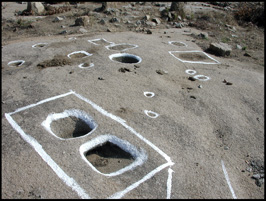
Figure 7: Architectural and other features visible along the North Ridge—including an 'elephant tie' in the foreground.
Some of the main features that we commonly record at Vijayanagara, for example, are the surviving stone foundation courses from destroyed building walls or the rock cut seatings for such walls. Because much of Vijayanagara sits on a series of hills and valleys composed of granite, many of the ancient city's architectural and structural features were chiseled directly into the rock and are still highly visible. These and other distinct features can be divided into hundreds of unique categories, such as: door pivots, anchor holes, mortar holes, beam sockets, quarry marks, rock cut oil lamps, and sculptures, gaming boards, anchor holes for walls, elephant ties, ...etc. (Figs.: 7 and 8).
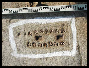
Figure 8: A gaming board, cut out of the living rock, on the North Ridge.
All of our data is stored in two simple and standard formats; tab-delimited and comma separated, since we can neither predict future technologies, nor can we assume that current forms of software will survive into the distant, or even the near, futures.
The data collection software linked to our surveying instruments allows us to customize two forms of data that are entered with each point we shoot: control codes and feature codes. The control codes function as sets of instructions, used by the CAD program in order to draw lines and points. They indicate that each and every survey point is one of the following:
| Abbreviation | Literal Meaning | Instruction to "Vectorworks" (CAD) |
|---|---|---|
| 1.) "POB": | "polygon open begin" | the beginning point in a line |
| 2.) "POE": | "polygon open end" | the last point in a line |
| 3.) "PCB": | "polygon closed begin" | the beginning point in a polygon |
| 4.) "PCL": | "polygon close" | the last point in a polygon |
| 5.) "PPT": | "point in a polygon" | single point in a line or a polygon |
| 6.) "PT": | "point" | a single point. |
Whereas the control codes listed instruct the CAD program how to draw the surveyed points, another series of codes, called feature codes, act as a database describing each and every survey point in greater detail. The feature codes are also designed to prompt the total station operator to enter each necessary detail about every individual, surveyed feature and to provide uniformity among data sets (Fig. 9).
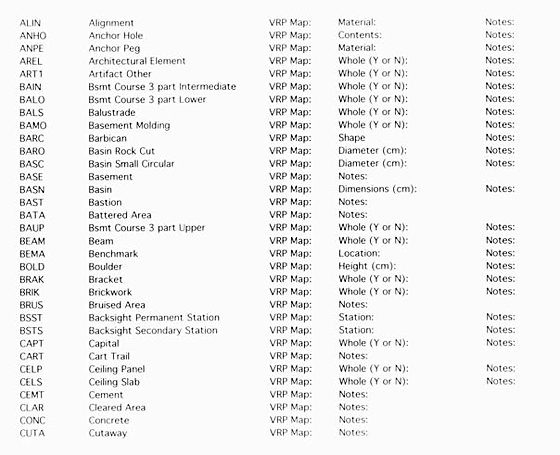
Figure 9: Page from the Archaeos' Vijayanagara Surveying Project's Field Manual, describing feature codes and their nested queries.
Every line of collected data ultimately contains the following information: 'control code', point number, X, Y, and Z coordinates, and the 'feature code' followed by its associated sub-categories of information.
A typical line of data exported from the data collector as a "raw", tab delimited line of values might read:
"PCB* 12 134.8642 24.2825 446.6322 PLFB VRP Map: N4E1 ' (Y or N): N." This line of information would be interpreted and utilized as follows:
| Raw Data | Meaning |
|---|---|
| 1.) PCB* | Instruction to CAD program to begin a polygon |
| 2.) 12 | Point number in set |
| 3.) 134.8642 | X coordinate |
| 4.) 24.2825 | Y coordinate |
| 5.) 446.6322 | Z coordinate |
| 6.) PLFB | Feature code = "pillar foundation block" |
| 7.) VRP Map: N4E1 | The reference to the VRP's 1:400 maps is "N4E1" |
| 8.) ' (Y or N): N | The artifact is no longer in its original position |
| 9.) Notes: Broken | The artifact has been broken |
The ability to customize these codes allows Archaeos to gather an unprecedented amount of information concerning each and every point shot. Since 2000, we have revised and recompiled these codes 20 different times.
Data modeling and analysis
At the end of each morning or afternoon surveying session, the collected information is downloaded onto a series of laptop computers. The data is then parsed into a standardized format using a series of custom written scripts and subsequently checked for errors by the surveyors. It is then imported into the CAD model.
This entire process is a hybrid solution to archaeological data collection in which we have learned to collect, model and analyze data that is specifically defined by archaeological reasoning, rather than by the limitations of "out of the box" hardware and software solutions. Any of the individual 'shots', or points, in the CAD generated maps can be selected and the viewer is able to see all of the control codes, feature codes and nested sub-categories of data associated with it by means of an object information window on screen.
Eventually, this data will be entered into a GIS platform allowing users to query the data in different ways.ix One might seek to learn, for example: how many of a specific feature exists within a defined space; or what the exact spatial parameters of a building, road, or field are. This type of data modeling will enable researchers and cultural resource managers to formulate new types of questions, analyses, and interpretations.
For example, the results of a query concerning artifact categories and resulting in a large number of mortars, grindstones, or other particular tool types within a specific area might indicate a high level of agricultural processing, or other forms of economic activity. A different set of questions concerning worn, rock areas might indicate ancient areas of intense physical circulation or of other types of usage by humans, or animals. Similarly, rubble mounds (one of our feature code categories) containing architectural elements such as, pillar foundation blocks, roofing slabs, or door lintels—which are recorded as sub-categories of the feature, might allow researchers to extrapolate building densities within given areas.
Our solution to data capture at Vijayanagara, built, as it is, upon various operating systems, custom scripts, and other kludges, is admittedly 'inelegant'. When we began our work in 2000, however, our goals could only be achieved by way of invention. We sincerely hope that in the near future integrated systems will be both readily and affordably available and that these will allow similar types of data collection and analysis to be conducted in a more streamlined, elegant, and user-friendly form.
The North Ridge
Although we believe that conservation and the protection of the site are important priorities, these goals must be balanced with very real and immediate human pressures. As foreign guests of the Indian state, our role in India is not that of cultural resource managers—indeed, we believe that any such suggestion would reflect imperialist and colonialist attitudes. Our role at Vijayanagara is simply to collect as much information as possible before it disappears; to try to suggest interpretations of the data that we collect; and to offer any assistance that we can to local archaeologists and state authorities.
Because so little is known about the North Ridge, which is heavily denuded and spans approximately four to five square kilometers in size, it has remained the primary area of our physical interest.
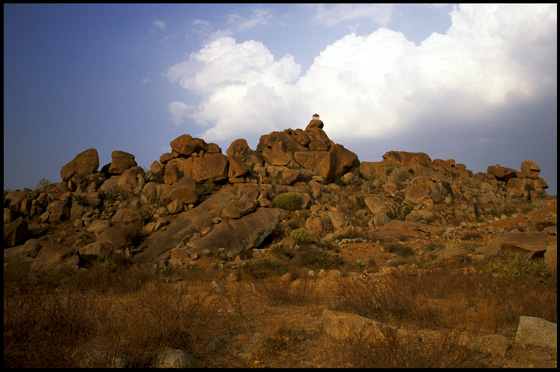
Figure 10: View of the North Ridge.
The remnants of roadways connecting the Royal Center to the Sacred Area of the ancient city and of smaller structures still left standing on the North Ridge were extensively cataloged during the 1980'sx by the Vijayanagara Research Project, but, it was traditionally assumed by archaeologists that only minor habitation existed in this area because so few structures are still left standing (Fig. 10). Our research there has already begun to change that perception by demonstrating that, at least within the sample area of the North Ridge that we are working in, almost every square meter of space was inhabited, or used, in some manner. During the Vijayanagara Empire, the North Ridge was, in fact a densely populated and vital portion of the Urban Core (Fig. 11).
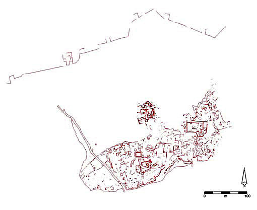
Figure 11: A two-dimensional CAD-drawn plan showing Archaeos’ surveying along the North Ridge.
Along the North Ridge, many important historical remains have disappeared, due to destruction, erosion, agriculture, or other human pressures upon the archaeological and ecological environments. Hundreds, if not thousands, of structures in this area, were destroyed either during the final siege of the capital, by subsequent erosion, or due to more recent looting for use as construction materials. These structures have never been recorded or described.
Over the past four field seasons, we have been recording the remains of these largely uncataloged and unmapped structures—along with any additional artifacts that may remain on the surface. Prior to this work, very little was known about the plan of this area, or about the density of settlement there. By focusing on surface remains, as opposed to excavating, we expect to eventually map a large portion of the building and habitation for the entire North Ridge. We envision that the information we are collecting will continue to enhance our knowledge of the distribution and uses of urban space within the city's core.
Noblemen's Quarter
In contrast to our research on the North Ridge, our work in the Noblemen's Quarter is intended primarily to provide an accurate plan of a series of official buildings already jointly excavated from approximately 1979 to the present by the Archaeological Survey of India (ASI) and the Karnataka Directorate of Archaeology and Museums (KDAM)xi. Our documentation began at the suggestion of Mr. H. T Talwar, the Deputy Director of the Karnataka Directorate of Archaeology and Museums.
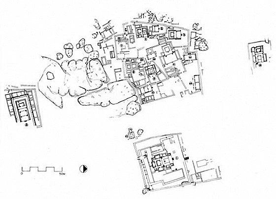
Figure 12: Earlier drawing of the Noblemen's Quarter (Devaraj, D and Patil, C. [eds.] 1991b:Fig. 2).
Rough plans were made of this area during and subsequent to the original excavations, but no accurate surveying of the structures was ever conducted, or published (Fig. 12). Such documentation is particularly important because this area is one of the few carefully excavated areas at Vijayanagara. Here, habitation remains have been recorded and described in situ and pottery and other artifacts have been excavated and recorded in a stratified context.
The Noblemen's Quarter contains upwards of a dozen brick and stone, plastered structures that were originally covered with organic roofing materials. Thus far, we have mapped more than three quarters of this area (Fig. 13).
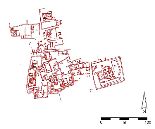
Figure 13: 2-dimensional, CAD-drawn plan showing Archaeos' surveying of buildings in the Noblemen's'
Quarter (NMQ).
These structures appear to have been linked to the administrative hierarchy of Vijayanagara, yet it is unclear exactly what their purposes were. They contain regularized, formally structured, ceremonial areas that suggest the function of official, semi-performative audience structures, rather than habitation units—an interpretation that is reinforced by the formal manner of circulation through the buildings (Fig. 14). In most cases, the circulation ultimately leads the visitor to a reception area in the form of a courtyard, which lies directly in front of a raised platform. The platform bears a room in its center with a door facing the reception area. Usually, there are several, stairways to either side of the platform, facing the courtyard.
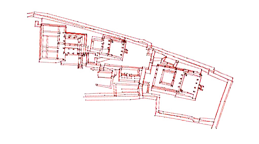
Figure 14: 3-D Wireframe rendering of several building complexes within the Noblemen's' Quarter (NMQ),
containing ceremonial platforms, standardized courtyards, and regularized manners of circulation.
It can be assumed that the presiding 'official' sat upon some sort of chair, throne, or dais, within the central room and that visitors, or supplicants, were presented to the official in the courtyard. If granted permission, the visitors would then presumably ascend the platform via one of the staircases to conduct their business and then leave via the opposite set of stairs.
Our work in the Noblemen's Quarter's area is not a complex program of research, such as the work that we are conducting along the North Ridge. We are simply providing a series of accurate three-dimensional plans of important administrative areas for use by the Indian authorities and by future architectural and cultural historians.
The current state of research in the North Ridge and Noblemen's Quarter
In summary, Archaeos' mapping of the North Ridge and Noblemen's Quarter at Vijayanagara was conceived of, at least in part, as an experimental project. One of the goals was to see if new technologies of mapping could augment and enhance the methods being used by previous researchers. Another was to see if the study of previously unmapped areas would bring information that would significantly alter previous views of the settlement patterns or spatial layout of the city. By utilizing newer surveying technologies and by constructing new frameworks for electronic data collection, we have been able to bring a greater degree of accuracy to the ongoing documentation process.
The North Ridge has been presumed by many archaeologists and historians to have been largely uninhabited, during the Vijayanagara period; on most maps it shown simply as a barren topographical feature. The results of Archaeos' project have yielded a different picture. The 75,000 to 100,000 square meters that have been mapped by us thus far indicate an intense massing of architectural and other cultural remains and dense urban development and usage. What initially appeared to us to be so many disparate features may now begin to be understood—via the mapping process—both as the remains of coherent structures and complexes and as the indicators of intense economic and social activity. This largely denuded area, should now be accepted as a vital and central part of the Urban Core, a result that is hardly surprising given the position of the North Ridge, which is directly situated between the royal, walled complex of the Zanana Enclosure and the outer fortification walls of the Royal City.
The remainder of the North Ridge, as well as many other similar regions of the ancient capital, still need to be mapped in order to derive a more accurate representation of spatial organization of the medieval city's historical growth and functions.
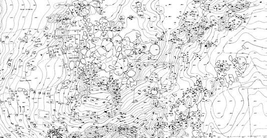
Figure 15: Several joined map sheets, showing the North Ridge, from the Vijayanagara Research Project (VRP) 1:400 Map Series (courtesy of John Fritz and George Michell).
Another important task is to either create new topographical maps in order to begin to interpret the ancient landscape, or to digitize pre-existing topographical surveys so that they may be reanalyzed. Archaeos has begun to transform the topographical map sheets produced by the Vijayanagara Research Project in the 1980's (Fig. 15) into digital form. This involves a laborious and tedious process of tracing the original map sheets into CAD format and manually keying in elevation data (Fig. 16). Fortunately, Karnataka, the state in which Vijayanagara is located is also the high-tech capital of India. We are fortunate in that the level of technical knowledge and expertise present in Karnataka has allowed us to involve members of the local community in the process of map digitization.
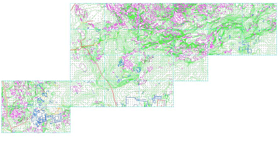
Figure 16: Digitized topographical map of the North Ridge and the Noblemen's Quarter, Vijayanagara by Archaeos (adapted from the VRP 1:400 Map Series).
The process of digitizing and geo-referencing the older VRP 1:400 maps for our the survey areas is critical for several reasons: it would be too costly and time intensive for Archaeos to create new topographic maps; a comparison between the digitized maps and our own survey data will also eventually allow us to better understand the accuracy of the earlier VRP survey; and—perhaps most importantly—these digital layers will eventually be incorporated into our survey's CAD renderings and an into eventual GIS analyses.
As we continue to work at Vijayanagara in conjunction with evolving technologies for measuring and analyzing space, we hope to continue to enhance our mapping, data collection, and analytical capabilities and to reach successively better levels of understanding of the ancient medieval city. We consider our understanding of the uses of urban space within the ancient city to be at a beginning rather than at a close. As we progress into a uncertain future—in which human cognition is ever more deeply linked to extracortical forms of data storage, analysis, categorization, communication, and representation—we hope that one positive benefit of our 'progress' will be that the rich resources of evolving cartographic, surveying, analytical, and computational methods will allow us to arrive at successively better understandings of how cities like Vijayanagara functioned.
Endnotes
i Paes, Domingos -1962 [1884]:247-248.
ii Fritz and Michell 2003:24.
iii Fritz and Michell 2003:28.
iv For the Sacred Center see: Michell, G. and P. B. Wagoner 2001.
v For the Urban Core see: Michell, G., Nagaraja Rao, M. 1990.
vi For the Royal Center see: Fritz, J. M., G. Michell, et al. 1984.
vii http://www.archaeos.org/vmp-season-2-3/html/GPSreadings.htm ; & http://homepage.univie.ac.at/elisabeth.trinkl/forum/forum1299/13syria.htm
viii http://www.archaeos.org/html/reportjs.htm.
ix We are opposed to utilizing "closed source"—i.e. commercially licensed—solutions at the site. We feel that the GIS software solutions licensed by corporations such as ESRI and ERDAS, and the database solutions licensed by companies such as Microsoft, are too expensive to ever see widespread use in developing countries like India. Such solutions, though they represent powerful analytical tools, limit the accessibility of information to genuinely interested parties such as scholars, students and cultural resource managers, while propagating unending blackmail and exploitation both by foreign monopolies and by individual programmers. When we eventually do implement a GIS solution for use with the data that we have been collecting at Vijayanagara, we expect that we will choose an "open source" licensed program, such as GRASS, linked to an "open source" database, such as MySQL.
x Michell and Rao 1990.
xi Nagaraja Rao, M., Michell, G. (eds.) 1983:14-29 and 1985:4-18; Devaraj, D., Patil, S. (eds.) 1991a:3-18; Devaraj, D., Patil, S. (eds.) 1991b:5-13; and Devaraj, D., Patil, S. (eds.) 1996:4-9; see also the descriptions of these structures and their contents in Sinopoli 1993.
References
Devaraj, D., Patil, C. (eds.) 1991a – Vijayanagara, Progress of Research, 1984-1987, Vijayanagara Research Centre Series 6. Mysore: Directorate of Archaeology & Museums Govt. of Karnataka.
Devaraj, D., Patil, C. (eds.) 1991b – Vijayanagara, Progress of Research, 1987-1988, Vijayanagara Research Centre Series 7. Mysore: Directorate of Archaeology & Museums Govt. of Karnataka.
Devaraj, D., Patil, C. (eds.) 1996 – Vijayanagara, Progress of Research, 1988-1991, Vijayanagara Research Centre Series 9. Mysore: Directorate of Archaeology & Museums Govt. of Karnataka.
Fritz, J., Michell, G. 2003 – Hampi. Mumbai: India Book House.
Fritz, J. M., G. Michell, et al. 1984 - Where Kings and Gods Meet: The Royal Centre at Vijayanagara, India. University of Arizona Press, Tucson.
Michell, G., Nagaraja Rao, M. 1990 – Vijayanagara, Architectural Inventory of the Urban Core (2 Vols.). Vijayanagara Research Centre Series 5. Mysore: Directorate of Archaeology & Museums.
Michell, G. and P. B. Wagoner 2001 - Vijayanagara, Architectural Inventory of the Sacred Centre (3 Vols.). New Delhi, Manohar.
Nagaraja Rao, M., Michell, M. (eds.) 1983 – Vijayanagara, Progress of Research, 1979-1983, Vijayanagara Research Centre Series 1. Mysore: Directorate of Archaeology & Museums Govt. of Karnataka.
Nagaraja Rao, M., Michell, M. (eds.) 1985 – Vijayanagara, Progress of Research, 1983-1984, Centenary Publication 1; Vijayanagara Research Centre Series 2. Mysore: Directorate of Archaeology & Museums Govt. of Karnataka.
Paes, Domingos - 1962 [1884] Narrative of Domingos Paes (Written Probably A.D, 1520-1522). Of the Things Which I saw and Contrived to Learn Concerning the Kingdom of Narasimga, Etc., in (ed.) Robert Sewell, A Forgotten Empire (Vijayanagara): A contribution to the history of India:229-278. Delhi: Ministry of Information & Broadcasting.
Sewell, Robert - 1962 [1884] A Forgotten Empire (Vijayanagara): A contribution to the history of India. Delhi: Ministry of Information & Broadcasting.
Sinopoli, C. 1993 – Pots and Palaces: The earthenware ceramics of the noblemen's quarter of Vijayanagara. Vijayanagara Research Project Monograph Series 1. New Delhi: Manohar.
Index
- Abstract
- Historical background
- The current state of the site
- Impetus and goals
- The conceptual 'zones' of the city
- Techniques and data collection
- The Surveying grid and its boundaries
- Structuring data collection and preparing the survey area
- Data modeling and analysis
- The North Ridge
- Noblemen's Quarter
- The current state of research in the North Ridge and Noblemen's Quarter
- Endnotes
- References