Projects : Built Heritage, Urban Planning, & Cartography
A critical component for understanding and maintaining cultural heritage sites is the surveying and mapping of landscapes, structures, artifacts, and other historical remains. Mapping, in the sense used here, entails not only conventional cartography, but also three-dimensional modeling of buildings and other site features.
Archaeology is perhaps understood by the majority of people to be about the discovery and physical excavation of ancient sites. Mapping is an integral part of that process, but it does not always go hand in hand with excavation. It may also be part of non-intrusive archaeological methodology, or technique, that focuses strictly upon recording unexcavated surface remains.
The aim of mapping projects often includes the investigation of:
- Urban planning.
- Uses of agricultural landscapes.
- Human settlement patterns and distribution.
- Current and historical uses of 'cultural spaces'.
- Movement of ancient and modern watercourses.
- Site erosion and degradation.
- Looting and vandalism.
- Modern land and site usage.
Mapping and cartography are, therefore, critical not only for understanding historical and cultural uses of buildings and spaces, but also for analyzing and comprehending the interaction of modern humans with ancient historical remains and to developing conservations, excavation, utilization, and other management plans for cultural patrimony.
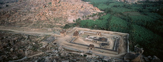
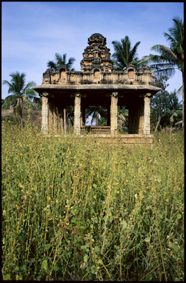
Vijayanagara (Hampi), India
Vijayanagara, which means "City of Victory" in the local Kannada language, was the capital city of the last great Hindu empire, of southern India during the 14th–16th centuries. The central city consists of a fortified royal residential quarter bordered by temple-centered religious communities and occupies an area of some 20 square kilometers and is surrounded by a larger metropolitan region that is estimated to occupy approximately 550 square kilometers.
Since December of 2000, Archaeos has been working in cooperation with the Karnataka Department of Archaeology and Museums to conduct a surface archaeology project, three-dimensionally mapping the remains of two areas of the ancient city.
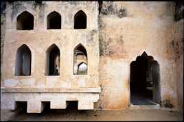
The major focus of Archaeos' research lies topographically along a long ridgeline, situated within the fortification walls of the Royal Centre. This area, known as the North Ridge, contains the remains of hundreds of small temples and buildings that are largely destroyed and poorly understood.
The North Ridge is now largely denuded and was long believed to have been only sparsely inhabited. The most significant outcome of Archaeos' cartographic and architectural project there has been the discovery that is was in fact densely populated. Within the areas of our cartographic survey there is in fact little, if any land that does not appear to have been built upon and inhabited, The results of this project indicate that the North Ridge should now be considered a central part of the urban core.
A secondary project for Archaeos is the re-mapping of a nearby area of the city, also within the Royal Centre, called the Noblemen's Quarter—which was originally excavated by archaeologists from the Karnataka Department of Archaeology and Museums and the Archaeological Survey of India.
The Noblemen's Quarter provides an important opportunity to better understand the spatial organization and functioning the elite, interrelated building complexes in this area, by means of using modern CAD and surveying technologies to create three-dimensional models.
At present, the future of Vijayanagara remains uncertain; the pressures of tourism, pilgrimage, and human habitation there have caused the UNESCO World Heritage Centre to place it on the List of World Heritage in Danger.
In 2002, Archaeos presented the results of its early work at Vijayanagara to UNESCO. We hope that, like so many others who are also involved in Cultural Heritage projects at Vijayanagara, we can help to bring added attention to importance of better understanding, conserving and managing the built remains and the cultural landscape of the last great Hindu empire.
The Vijayanagara Mapping Project is directed by Dr. David N. Gimbel (Archaeos) and co-directed by Dr. John M. Fritz (Associate Professor of Anthropology, University of Pennsylvania).
Links to Earlier seasons:
Related Resources
Archaeology and Anthropology
Cultural Heritage
- International Institutions & Organizations
- National Institutions & Organizations
- International Conventions
- International Pacts and Treaties
- International Laws and Statutes (Databases)
- UN Resolutions
- UNESCO Conventions
- UNESCO Recommendations
- UNESCO Declarations
- Miscellaneous UNESCO Documents
- ICOMOS Charters (General Assembly)
- ICOMOS Charters (National Committees)
- ICOMOS Resolutions and Declarations (Symposia)
- US Acts and Federal Statutes
- Other Charters & Standards