|
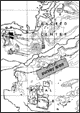
The topographical feature known as the North Ridge, which
is the project’s primary area of physical interest,
covers approximately 4-5 square kilometers of the site
and is centered between ‘Royal’ and ‘Sacred’
precincts, or areas, of the urban core (Figure 1). In
this area important historical remains have already largely
disappeared due to human pressures upon the archaeological
environment. Our aim is to record any surviving information
that is visible on the surface of the North Ridge. Because
the project focuses upon recording surface remains, as
opposed to excavating, we should eventually be able to
map a large portion of the extensive building and habitation
remains.
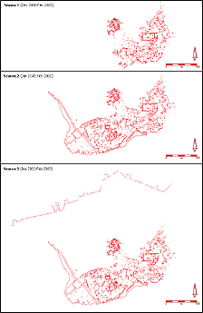
By utilizing state of the art surveying technology,
Archaeos has been able to bring a greater degree of
accuracy to the ongoing documentation process. Although
upon initial visual inspection the North Ridge today
appears to have been largely uninhabited in ancient
times, the results of the mapping process has already
yielded a very different picture, based upon the approximately
75,000 to 100,000 square meters that have been precisely
surveyed by the Archaeos’ team thus far (North
Ridge Progress).
The numbers and the massing of architectural and other
cultural remains along the surface of the North Ridge,
in fact, indicate dense urban development and now that
many of these disparate features have been mapped, they
can be more easily understood as the remains of coherent
structures and indicators of economic and social activities.
It is clear that this now largely denuded area, which
was long thought to have been only sparsely inhabited
during medieval times, was in fact a densely populated
area that should be considered to have been a central
part of the urban core. This result is hardly surprising
given the position of the North Ridge. It is directly
situated between the royal, walled complex known as
the Zanana Enclosure and the outer fortification walls
of the Royal City.
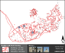
Of particular interest in the projects’ survey
area are several large buildings that had been very
roughly indicated on the VRP’s 1:400 survey maps
from the 1980’s. One of these buildings had also
been previously drawn by a separate archaeological team
using
hand held tapes. Archaeos’ re-surveying of that
area using modern surveying techniques, however, has
revealed many inaccuracies that occurred due to the
older technologies and techniques that had been employed.
|
 |
|